
Some projects don’t translate from the ground. This was one of them.
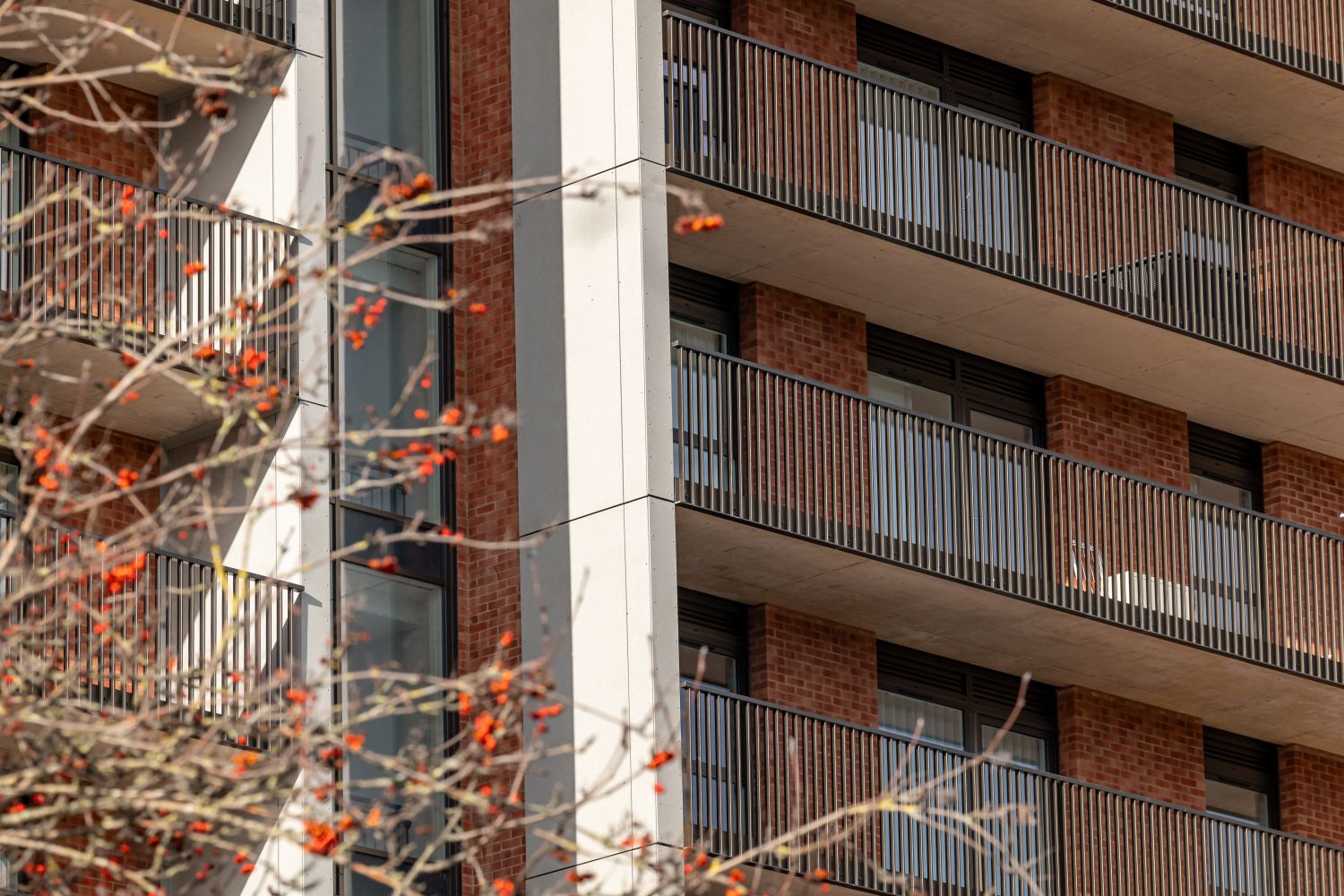
Maple Facades had installed a reconstituted stone rainscreen cladding system across the full height of a 16-storey building at Bedminster Green – along with balustrades and architectural fins that only read properly when you’re level with them. The brief was to document what had been installed and show the building at scale within Bristol through the use of drone photography and select ground photography. From the pavement, neither of those things is possible.
This is an account of how the project was planned and delivered, and why drone photography was the only viable approach.
Bedminster Green Bristol: Drone Photography on a 16-Storey Residential Building
The building sits within the wider Bedminster Green regeneration scheme, one of Bristol’s most significant ongoing development programmes, transforming a cluster of brownfield sites south of the city centre into residential-led mixed-use space.
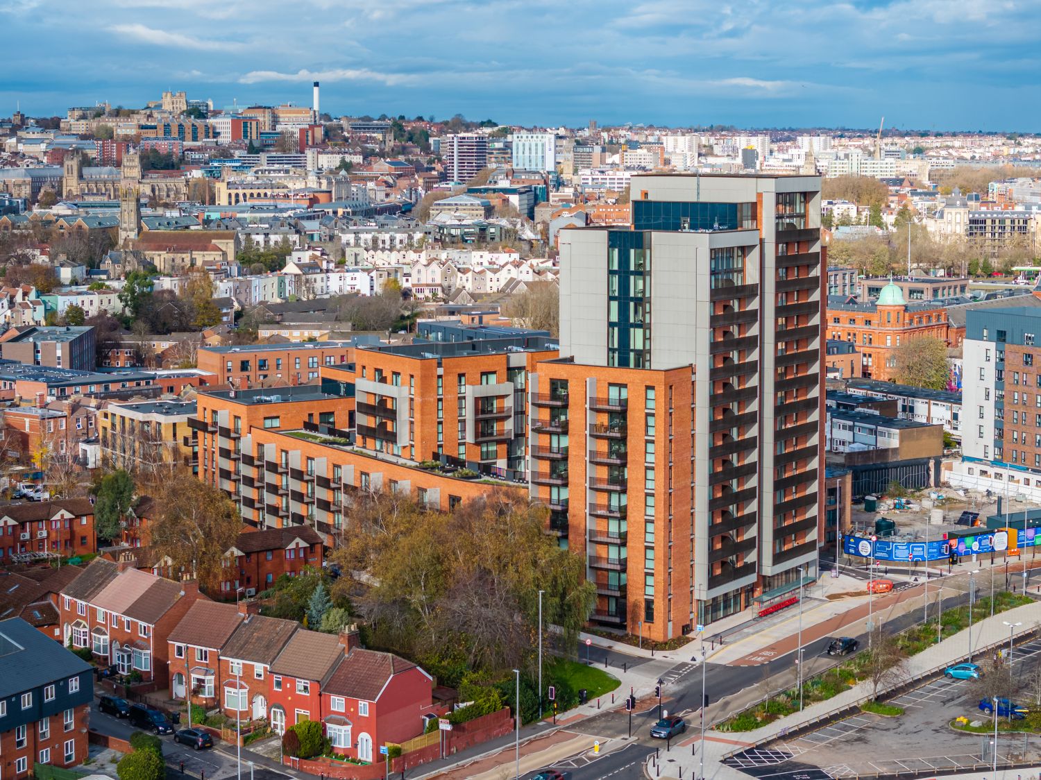
Plot 4a on Stafford Street – was completed by main contractor Dandara Living in Spring 2025, delivering over 300 residential units across 16 storeys. The scheme represents exactly the kind of high-density urban development that Bristol’s housing pipeline depends on, and it sits in a correspondingly complex environment: tight streets, active pedestrian routes, proximity to rail infrastructure, and neighbouring buildings on multiple sides.
That density is also what makes the building so difficult to document properly. You can stand back far enough to see the roofline, or you can stand close enough to see the lower floors. You cannot do both at once, and you cannot get alongside the facade at the 10th or 14th floor without either scaffolding or a drone.
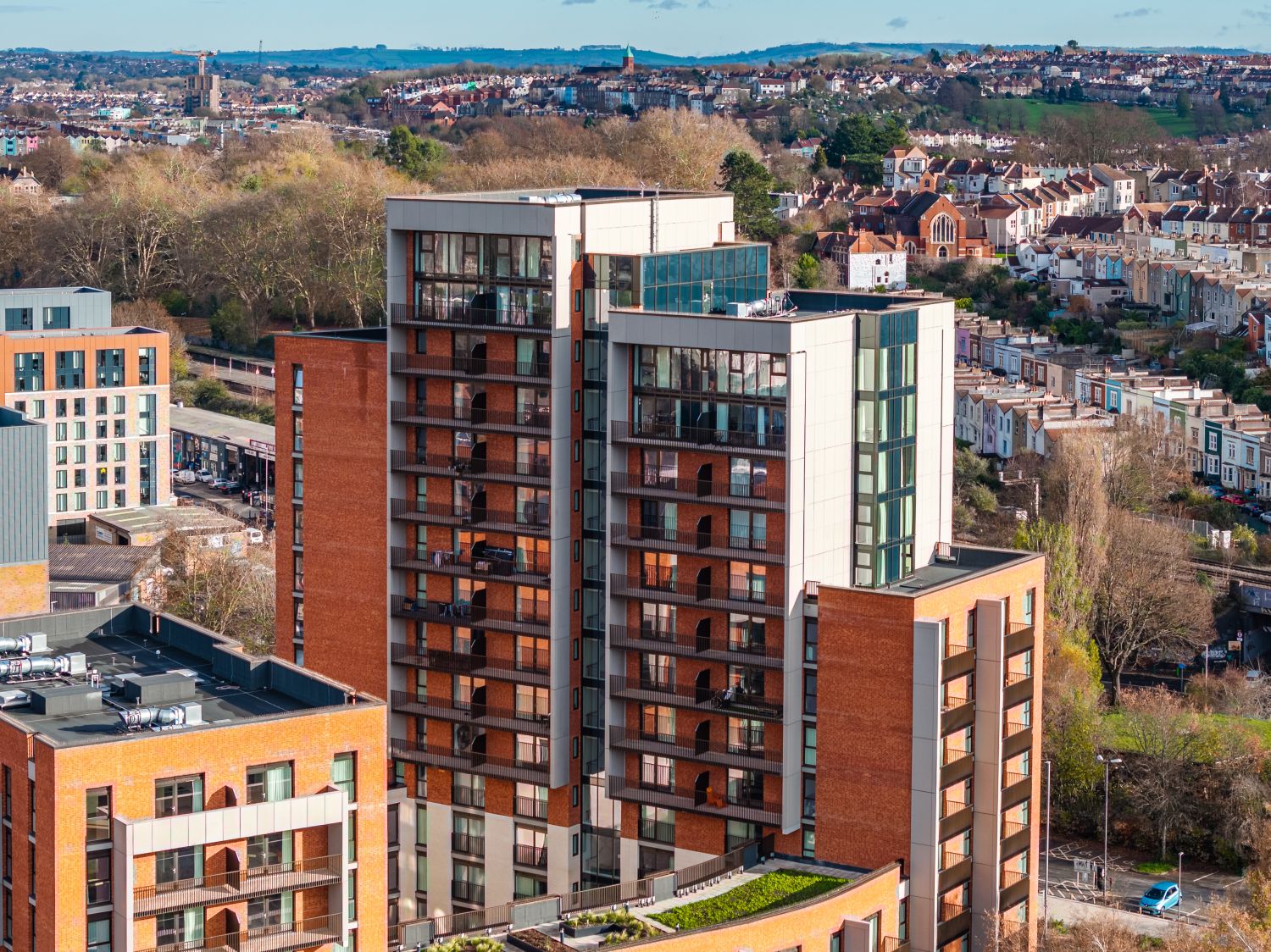
Maple Facades’ scope covered the full building envelope: reconstituted stone rainscreen cladding across multiple elevations, architectural fins, and balustrade systems at every level. These are elements that need to be seen properly to be understood – and properly, in this case, means from the air.
Why High-Rise Facade Projects in Bristol Need Drone Photography
This is worth addressing directly, because the limitations of ground photography on a project like this aren’t just inconvenient – they make certain images functionally impossible.
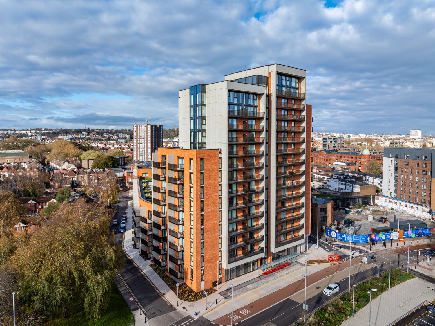
From street level, a camera pointed upward at a 16-storey building produces extreme perspective distortion. Vertical lines converge, proportions compress, and the upper floors – often where the most complex or high-specification work is concentrated – become distant and indistinct. Wide-angle lenses make this worse. Telephoto lenses help with compression but remove context entirely.
More fundamentally, ground photography cannot get alongside the facade at height. You can look up at the balustrades on the 12th floor, but you cannot photograph them from the same elevation. You can see that architectural fins exist on the upper levels, but you cannot capture their profile, their fixing detail, or their relationship to the cladding panels behind them.
For a contractor like Maple, whose portfolio and tender submissions need to demonstrate capability on complex, high-rise, high-specification installations, this matters enormously. Images that show the work from below don’t prove what the work actually looks like. Images taken from the air, level with the installed elements, do.
Planning Drone Photography in Bristol’s Urban Environment
Executing drone photography in a dense Bristol city environment requires more advance planning than most clients expect. The flying itself is often the straightforward part.
Finding a viable take-off point
Operating a larger drone like the DJI Mavic 3 Pro in a built-up area requires a take-off location that allows safe operation within CAA regulations, maintains a minimum 30-metre separation from uninvolved people, and provides a clear, unobstructed line of sight to the subject building. Around an active residential development on a constrained urban site, that combination isn’t always obvious. It requires a site visit or detailed mapping review before the shoot day.
Choosing the right equipment for the environment
Two drones were used across this project, selected for different situations. The DJI Mavic 3 Pro handled the primary elevation shots – controlled, high-quality captures at distance and height, where image quality and stability were the priority. The DJI Mini 4 Pro was used for closer work over streets and in tighter airspace, where its sub-250g classification gives more operational flexibility in congested areas. Using both meant the shoot could adapt to the environment without sacrificing image quality or compromising on safety.
Controlling light across a 16-storey facade
Light management on a building of this height is a genuine technical challenge. A north or south-facing elevation can shift from well-lit to fully shadowed within an hour depending on time of day and season. Harsh directional light at the wrong angle creates shadows that obscure cladding detail and make images commercially unusable. Shoot timing was selected specifically to bring out the texture of the reconstituted stone, maintain even illumination across the full elevation height, and avoid the kind of high-contrast shadow patterns that flatten surface detail.

Coordinating with the site team
Drone operations alongside an active or recently completed development require coordination with the principal contractor. For this project, that meant confirming access points, establishing awareness of any ongoing site operations, and ensuring the flying programme integrated safely with activity on and around the building. Dandara Living’s site team facilitated this without difficulty.
Bristol Drone Photography: Capturing Cladding and Facade Detail at Height
The core of the brief was documentation – making sure that what Maple installed was clearly visible and identifiable in the final images.
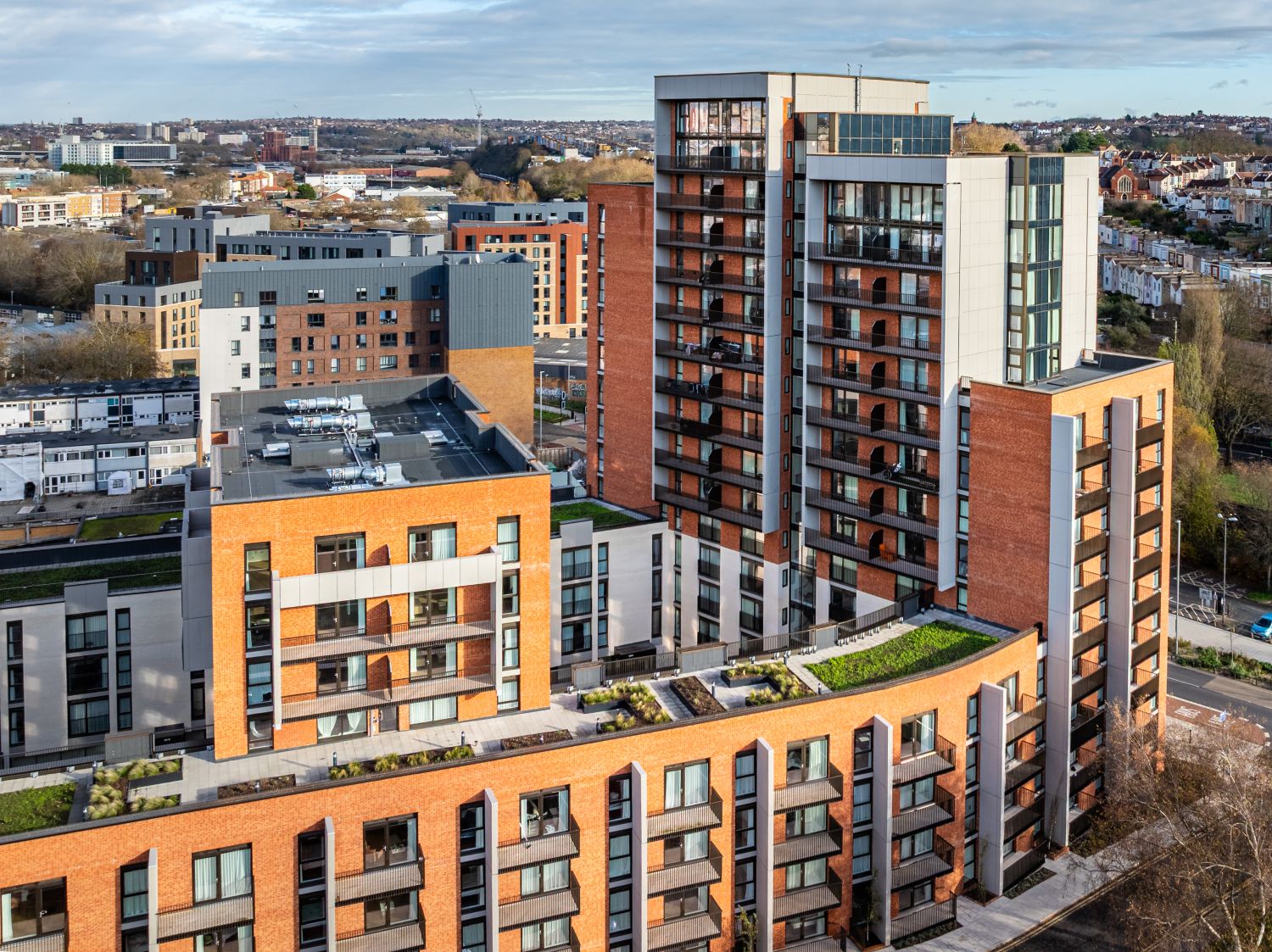
That required a systematic approach to the facade rather than simply flying the drone and selecting the best frames. Each elevation was assessed for the installed elements it contained: the cladding panels and joint lines, the profile and positioning of the architectural fins, the balustrade systems and their relationship to the floor plates. Drone positions were then chosen to capture these elements at useful angles – close enough to read the detail, at the right height to avoid distortion, with enough separation to provide context about where on the building each element sits.
Upper-floor details that are completely inaccessible once scaffolding is struck – balustrade fixings, cladding returns, fin connections – were captured at close range from the air. These are the images that don’t exist in any other form once a project is complete. They can’t be recreated without re-erecting access equipment.
Drone Photography Placing the Building in the Bristol Skyline
Detail images answer the question of what was installed and how it looks. Context images answer a different question: what kind of project is this, and what is the contractor capable of?
Wider drone shots pulled back to frame the building within its surroundings – across Coronation Road, toward Victoria Park, and into the broader Bristol city centre skyline. At 16 storeys in a predominantly low-rise neighbourhood, the building reads clearly from distance, and those wider frames communicate scale in a way that close-up detail images cannot.
This combination – facade detail and cityscape context in a single edited set – is what makes the imagery commercially functional rather than simply visually interesting. A portfolio page or tender submission that shows only close-up cladding detail tells an incomplete story. One that shows the scale of the project, the building’s presence in Bristol, and the quality of the installed work at close range tells the complete one.
Ground Photography Supporting the Bristol Drone Shoot
Ground photography played a supporting role on this project rather than a primary one. Using lenses in the 17-200mm range, it focused on street-level elements: the building’s entrance, its interaction with the public realm, and upward perspectives of the lower balconies and facade lines where ground-level viewing angles were usable.
This isn’t a criticism of ground photography – it’s a recognition of what it’s for. On a 16-storey project, it anchors the building at pavement level and provides images that the drone, by nature of its altitude, cannot. Used selectively alongside the aerial work, it completes the set.
Bristol Construction Photography: Deliverables for Facade Contractors
The edited image set from Bedminster Green was delivered for direct use in Maple Facades’ portfolio and tender documentation – no further processing required on their end.
Editing focused on accurate colour representation of the stonework and cladding materials, clean and consistent grading across the full set, and shadow and highlight control that preserved surface detail without artificial enhancement. The goal was images that represent the work accurately and professionally, not images that flatter it beyond recognition.
For contractors working at this level, photography serves a specific commercial function. Tender submissions for high-rise, high-specification projects are evaluated partly on demonstrated capability – and demonstrated capability means showing finished work on comparable schemes, photographed in a way that makes the quality of the installation legible. Images taken from the pavement looking up don’t achieve that. Images taken from the air, level with the work, do.
Drone Photography Bristol: What This Project Demonstrates
Bedminster Green is a useful case study not because it was unusually complex to photograph, but because it illustrates clearly why drone photography is often not optional on high-rise commercial projects in Bristol.
The building couldn’t be documented from the ground. The installed elements couldn’t be shown at the specification quality a professional portfolio requires. The scale of the project couldn’t be communicated without aerial context. None of those things are true of a two-storey retail unit or a low-rise residential scheme – but they are consistently true of high-rise facade work, and that’s the category of project where the investment in drone photography pays back most directly.
For contractors like Maple, the images from a project like this have a working life that extends well beyond the project itself. They appear in tender submissions for years. They anchor portfolio pages. They do a specific commercial job – and doing that job properly requires getting the photography right when the opportunity exists, which is to say, before the scaffolding comes down.
If you’re delivering a high-rise project in Bristol and need imagery that actually shows the work properly, this is where drone photography becomes essential.
It’s not about getting aerial shots – it’s about capturing information that would otherwise be lost once access is removed.
If you’re working on a similar scheme in Bristol and need to document it properly, you can contact me about your project.