
Land that carries planning permission rarely sells itself. The marketing has to do a lot of the heavy lifting – often within a small, targeted pool of buyers who know exactly what they’re looking for. Get the imagery wrong and a site can sit on the market longer than it needs to. Get it right, and the right buyer finds what they need quickly.
This is a case study from a recent instruction we completed for Connells, capturing drone photography and ground photography for a land sale near Yate, Bristol.
Why Drone Photography for Land Sales Is Different
Photographing land for sale requires a different approach to standard property photography. The land itself is often just part of the story. Buyers and developers want to understand the wider context – the surrounding environment, access routes, transport links, nearby infrastructure, and how the site sits within its locality.
From the air, all of that becomes immediately legible. A well-executed set of aerial images can communicate in seconds what a written description might take several paragraphs to explain.

At Aircam Drone, we hold a CAA GVC (General Visual Line of Sight Certificate), which means we’re authorised to operate commercially across a wide range of environments, including sites close to roads, buildings, and populated areas – the kind of locations that frequently come up in land sale instructions across Bristol and the wider South West.
The Project: Land with Outline Planning Permission Near Yate
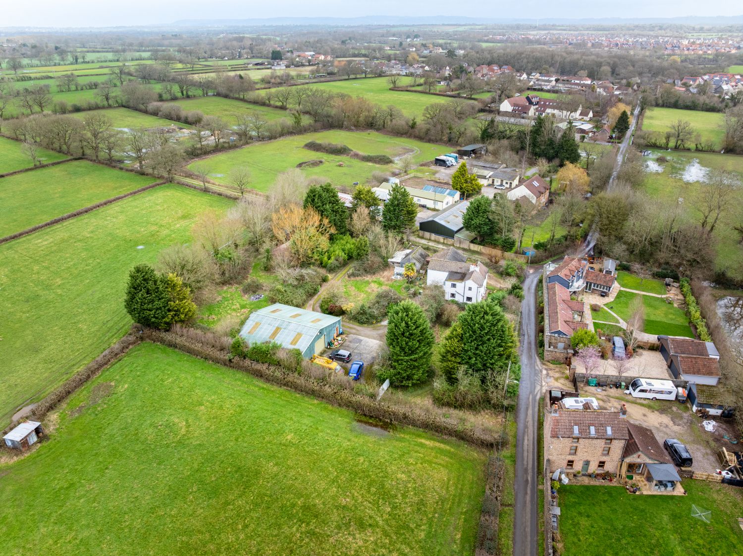
We were instructed by Connells to capture photography for a site near Yate, a market town in South Gloucestershire sitting on the northern edge of the Bristol commuter belt.
The property comprised an existing dwelling together with a parcel of land that had been granted outline planning permission for new residential development. This kind of mixed instruction – an existing home alongside a development opportunity – requires imagery that serves two distinct audiences: those interested in the residential element, and those focused on the development potential of the land.
Properties of this type don’t always reach the open market. They’re often handled through targeted marketing to a curated network of developers, investors, and land buyers. That means the imagery needs to work harder. There’s less opportunity to rely on a high volume of viewings to carry the marketing.
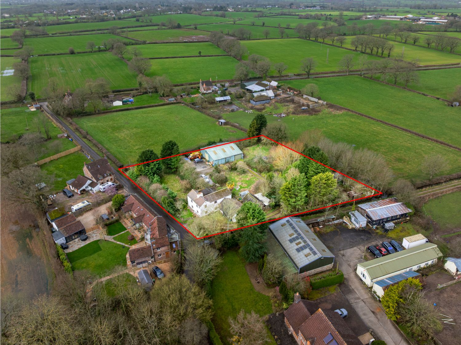
What We Captured: Annotated Aerial Imagery
Our starting point on every land instruction is a short conversation with the client to understand what the marketing needs to achieve. For this project, the priorities were clear: show the layout of the land, its access, its position within the village, and the existing dwelling.
We photographed the site from multiple angles and altitudes to build up a complete picture. The land was level and flat – a genuinely positive feature for any developer assessing groundworks costs – and that needed to be visible in the imagery.
The village setting also mattered. Being able to see the surrounding context from the air – established housing, green space, road access – helps a buyer understand the nature of the location without needing to visit first.
Annotated Drone Images
For this instruction, we produced a set of annotated drone images. Annotations are something we use regularly on land sale projects, and for good reason. Rather than leaving a buyer to interpret what they’re looking at, annotations overlay key information directly onto the image – site boundaries, access points, neighbouring parcels, and planning reference areas.
Done well, annotated aerial imagery turns a photograph into a working document. It reduces back-and-forth between agents, solicitors, and buyers by putting the critical spatial information front and centre.
Video wasn’t required for this particular instruction, so we focused entirely on delivering a strong set of stills.
Combining Drone and Ground Photography
Alongside the aerial work, we also provided full ground-level photography of the existing dwelling – both external and internal.
This is something we offer as standard on instructions where a property includes a building as well as land. Combining aerial and ground photography in a single visit is more efficient for all parties, particularly when time is a factor, as it often is in land sales.
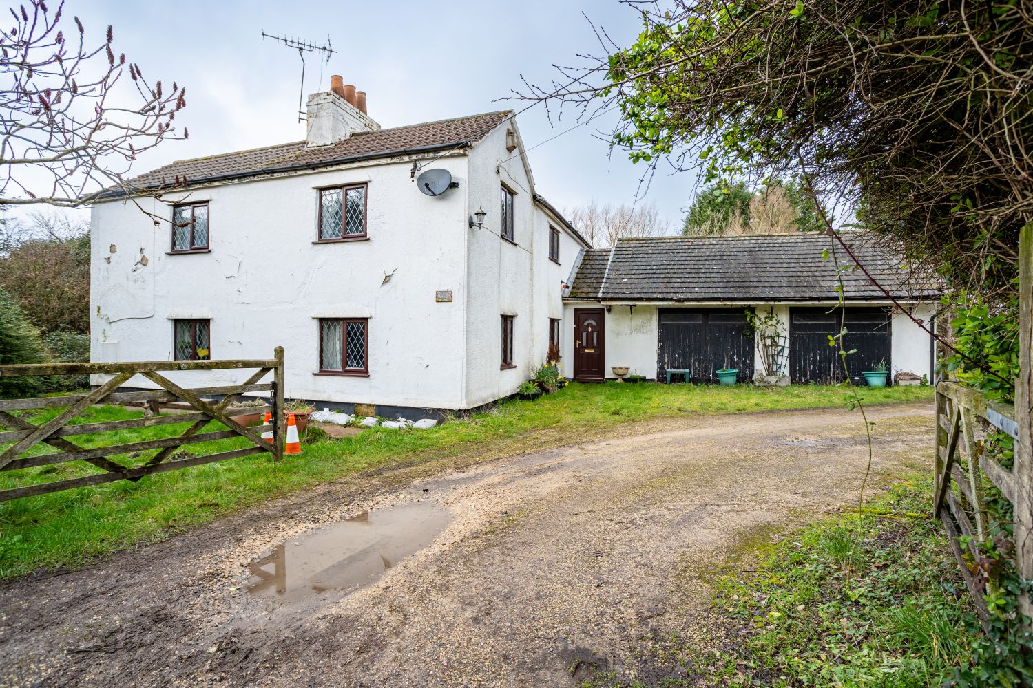
For Connells, this meant a complete set of marketing imagery captured in one appointment: aerial coverage of the land with annotations, plus a full internal and external record of the house. Everything needed to go to market, from a single instruction.
What Good Drone Photography for Land Sales Actually Involves
We’re often asked what separates a professional drone operator from someone with a consumer drone and a camera. For general lifestyle or event photography, the gap can be relatively small. For land sales, it tends to be much larger.
Here’s what we bring to this kind of instruction:
Regulatory compliance. Operating commercially as a drone pilot in the UK requires CAA registration and, for more complex operations, a GVC or equivalent qualification. We hold a CAA GVC, which allows us to fly in a wider range of environments safely and legally.
An understanding of what buyers and agents need to see. We work regularly with estate agents, land agents, and property developers across Bristol and the South West. That experience means we know how to frame a site – what angles matter, what the imagery needs to communicate, and how to structure a set of images that support the marketing rather than just document the location.
Annotation capability. Not all drone operators offer annotated imagery. It’s a step beyond capturing the photographs and requires an understanding of what spatial information is relevant to the transaction.
Combined ground and aerial. Being able to cover both in a single visit keeps things simple for agents and clients, and ensures visual consistency across all the marketing material.
What the Client Said
The feedback from Connells on this project was straightforward – the imagery did its job.
On delivery of the photography, Paul Matthews from Connells Land told us: “They look great, thank you for these!”
More broadly, Connells have shared this about working with Aircam Drone across multiple instructions:
“We’ve worked with Aircam on several projects involving photography, drone photography, and video. They consistently deliver high-quality, accurate content that supports our marketing efforts. Aircam are responsive, accommodating, and quick to turn projects around. We’re happy to recommend their services.”
Jack Underwood, Connells Land
For agents and land teams, responsiveness and turnaround time matter as much as the quality of the imagery itself. Land sales can move quickly, and marketing material that arrives late can cost a sale. Keeping to timelines and communicating clearly throughout is something we take seriously on every instruction.
Working with Agents and Land Teams Across the South West
We’re regularly instructed on land sales, development sites, and mixed-use properties across Bristol, South Gloucestershire, and the wider South West. Whether a site is straightforward or more complex – constrained access, multiple parcels, proximity to infrastructure – we’re used to adapting quickly and delivering imagery that’s ready to use.
If you’re handling a land instruction and want to discuss what we can provide, we’re always happy to have a conversation first. Most projects start with a brief call to understand the brief, and we take it from there.
Aircam Drone is a CAA GVC-certified drone operator providing aerial photography, video, and annotated imagery for land sales, property marketing, and surveys across Bristol and the South West.