
Introduction to Photogrammetry
Photogrammetry, a term coined by Prussian architect Albrecht Meydenbauer in his 1867 article “Die Photometrographie,” is a multifaceted science and technology. It is defined as the process of obtaining reliable information about physical objects and environments through the recording, measuring, and interpreting of photographic images and patterns of electromagnetic radiant imagery, among other phenomena. This technique has evolved significantly from its initial use in plotting contour lines on topographic maps. Today, photogrammetry encompasses various applications, ranging from close-range photography to using remote sensing for complex 2D and 3D motion field analysis. Its versatility extends to numerous fields, including drone mapping, where it plays a critical role in accurately capturing and analysing terrain and environmental data.
Understanding Drone Based Photogrammetry
The nature of drone-based photogrammetry lies in its ability to capture images from multiple vantage points, which are then stitched together to form a comprehensive picture of the surveyed area using software by specialist developers like Pix4D. This process hinges on a critical factor known as ‘overlap’. Overlap in drone surveys refers to the amount of repetitive coverage present in consecutive images taken during a drone flight. It is categorised into two types: front overlap (longitudinal) and side overlap (lateral). These overlaps are not mere redundancies; they are vital for ensuring that the final stitched image is seamless and free of gaps or inaccuracies.
The Importance of Overlap
Understanding and mastering the concept of overlap is crucial for drone operators and surveyors. The right amount of overlap can significantly impact the quality of the photogrammetric outputs. Too little overlap might lead to incomplete data and potential gaps in the final mapping product, while too much overlap could result in an unwieldy amount of data, making processing and analysis cumbersome and time-consuming.
The objective of this article is to provide an in-depth guide for drone operators and surveyors on how to achieve optimal results in drone mapping through effective overlap techniques. Whether you are a seasoned professional or new to the field of drone mapping, this article aims to enhance your understanding of overlap and its importance in photogrammetry, guiding you toward more accurate, efficient, and reliable mapping outcomes.
Section 1: Understanding Overlap in Drone Mapping
Defining Overlap
In the realm of drone mapping, overlap plays a pivotal role. It refers to the amount of common area that appears in multiple photographs taken during a drone flight. This concept is divided into two primary types:
Front Overlap (Longitudinal Overlap): This is the overlap between consecutive images taken along the flight path of the drone. It ensures that each point on the ground is captured in multiple images from different vantage points, enhancing the detail and depth of the final map.
Side Overlap (Lateral Overlap): Side overlap occurs between images taken across adjacent flight paths. It is crucial for creating a continuous and comprehensive coverage of the surveyed area, especially in larger or more complex landscapes.
Contribution to Photogrammetric Outputs
Overlap is not just a technical requirement; it is a critical determinant of the accuracy and quality of photogrammetric outputs. Here’s how:
Enhanced Accuracy: By capturing the same area from multiple vantage points, overlap allows for more accurate alignment and integration of images. This multiview approach reduces errors and improves the precision of the final 2D maps or 3D models.
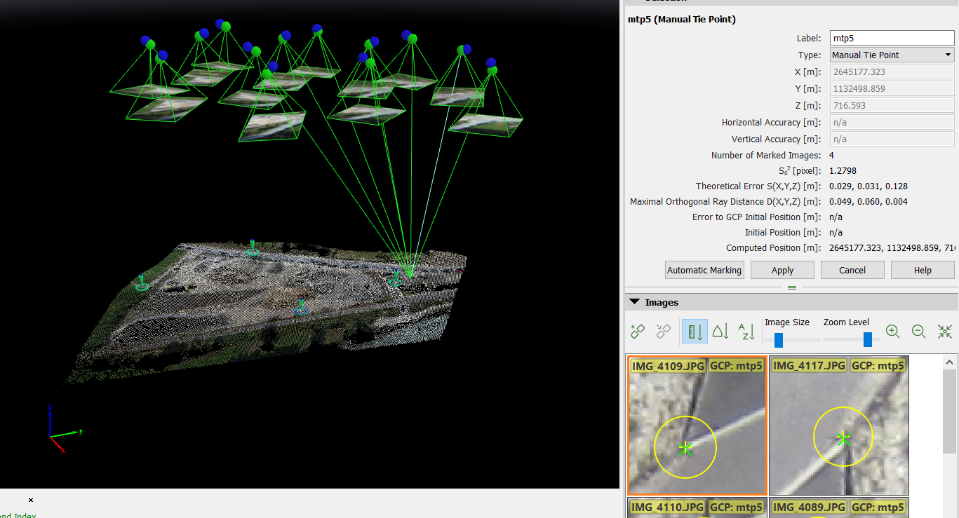
Quality of Image Stitching: Effective overlap is essential for seamless stitching of images. In photogrammetry, software algorithms use overlapping areas to find common points between images (tie points), enabling them to merge the photographs accurately. Insufficient overlap can lead to gaps or misalignments in the final product.
Depth Perception and 3D Modeling: Overlap contributes significantly to the creation of 3D models. The different angles captured due to overlap enable the software to calculate depth and elevation, creating a three-dimensional representation of the surveyed area.
Drone Data Capture Basics
Drone mapping involves planned flights where the drone systematically captures images of the ground below. These images are then processed to create maps or 3D models. The role of overlap in this process is multi-faceted:
Flight Planning: Overlap is a critical consideration in planning the drone’s flight path. Operators must determine the appropriate level of front and side overlap based on the specific requirements of the project.
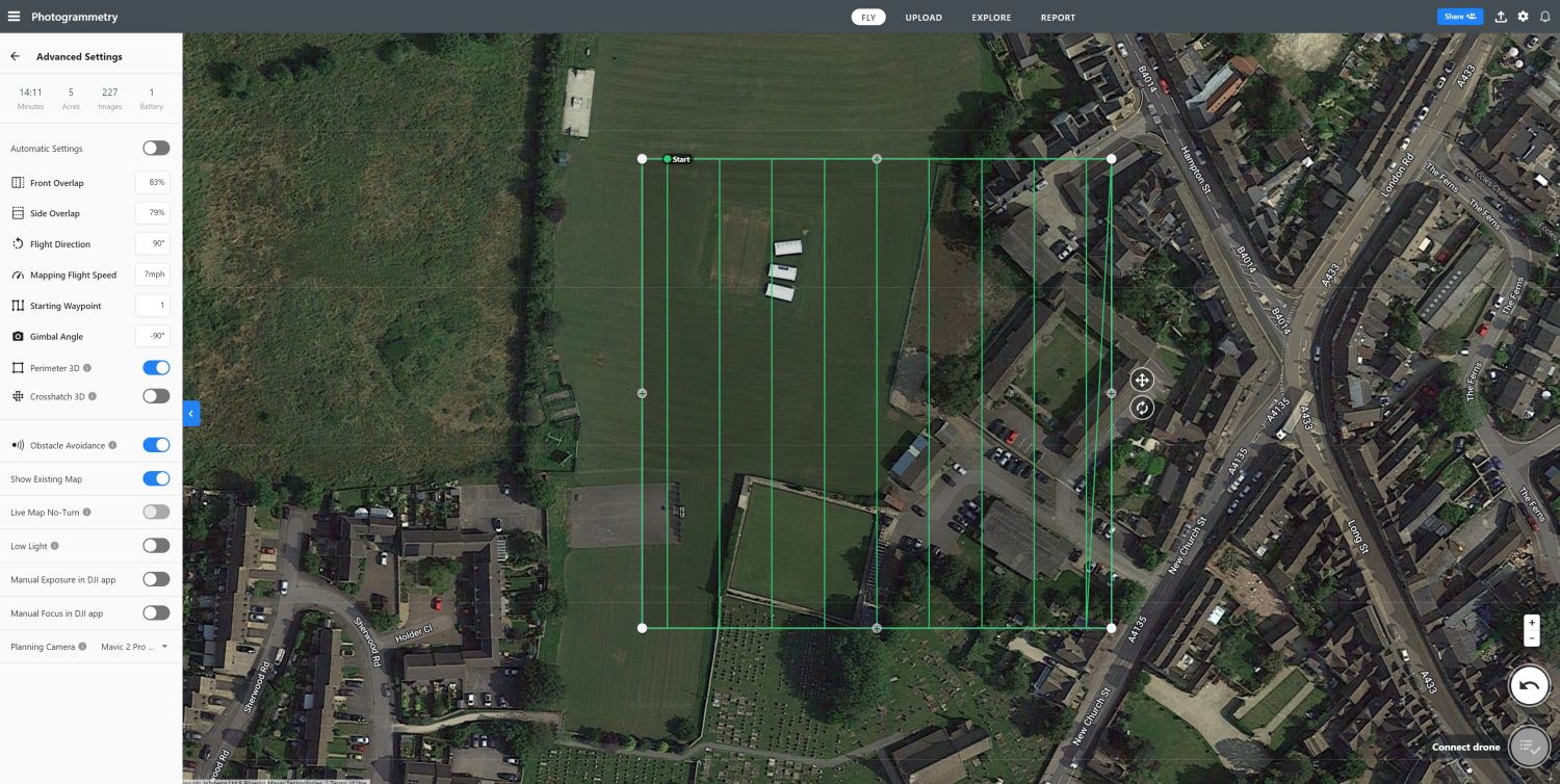
Image Capture Consistency: Consistent overlap ensures that the drone captures every part of the area in detail. It requires precise control over the drone’s speed, altitude, and camera settings, which are all usually automated.
Post-Processing Efficiency: The right balance in overlap not only ensures accuracy but also impacts the efficiency of post-processing. Too much overlap can lead to inordinate amounts of data, slowing down the processing time, while too little can result in inadequate coverage and poor-quality maps and models.
In summary, understanding and managing overlap is crucial for successful drone mapping. It requires careful planning, precise execution, and an understanding of how this element influences the entire photogrammetry process.
Section 2: Factors Influencing Optimal Overlap
Terrain Complexity
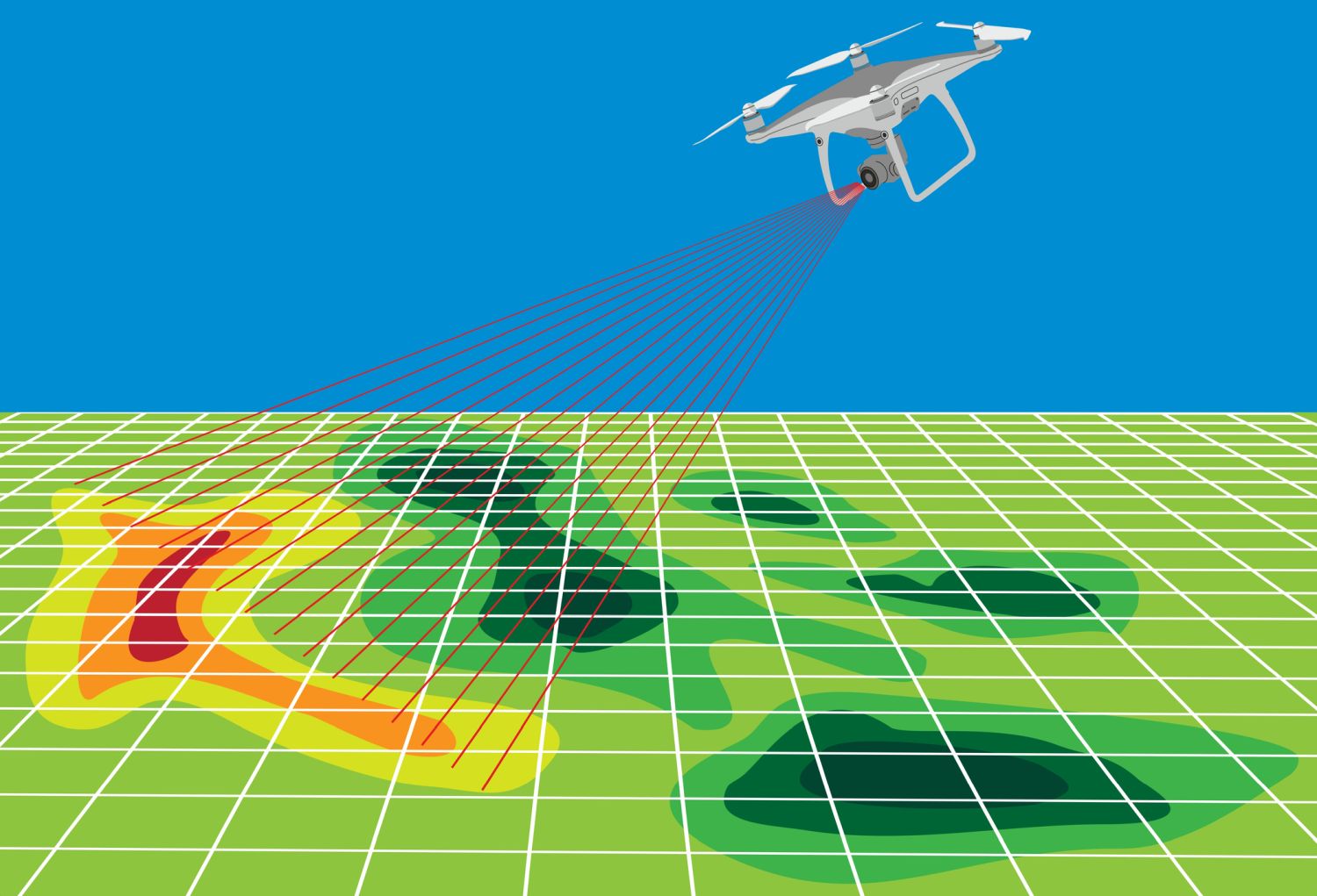
The complexity and character of the terrain are critical in determining the necessary overlap for drone mapping. Homogeneous landscapes, such as agricultural fields, large water bodies, snow-covered areas, and dense forests or vegetation, pose a unique challenge. These environments lack distinct, varying features, making it difficult for photogrammetry software to identify tie points – crucial reference points needed for stitching images together to create accurate 2D maps and 3D models. Consequently, these types of terrain require a higher overlap. This increased overlap ensures that enough data is captured, allowing the software to reference more images to create accurate tie points.
In contrast, terrain with varied features, like urban environments or areas with distinct geological formations, provide more unique visual elements. These elements facilitate the software in identifying tie points, potentially allowing for slightly less overlap compared to homogenous areas.
In built-up urban environments, you may need to increase overlap to see between buildings.
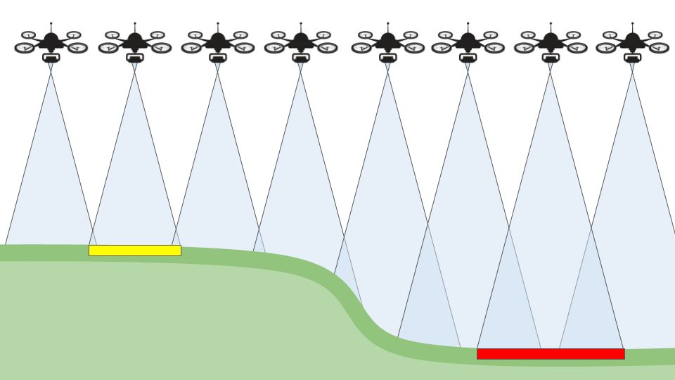
Terrain Relief
If the terrain is particularly undulating or there are high buildings within your planned mapping area, then overlap may need to be increased. This is because of the intrinsic reduction in overlap over the high points of your survey area, potentially leading to gaps in data. Some drone planning software has built-in ‘terrain awareness’ functionality which uses maps to adjust the height of the drone, taking topographical relief into account.
Environmental Conditions
Environmental factors, such as lighting and weather, also play a significant role. Good lighting conditions improve image quality and assist in identifying tie points. Conversely, poor lighting conditions, like overcast skies or low-light environments, may necessitate a higher overlap to compensate for reduced visibility and ensure enough data for accurate image processing.
Section 3: Overlap Recommendations for Different Scenarios
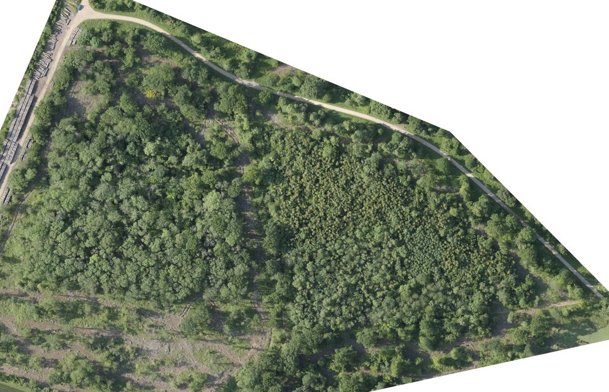
Homogenous Terrain (snow, sand, water surfaces, fields, trees)
For terrain with little discerning visual content such as snow, sand, water, fields, and trees, a high overlap is essential due to large uniform areas. The recommended overlap is 80% frontal and side overlap for fields and 85% frontal and side overlap for forests and dense vegetation. These settings allow photogrammetry software to identify tie points by giving references from more images. It’s important to note that oceans are generally impossible to reconstruct due to their uniformity.
Urban Areas
Urban areas, particularly for city reconstruction involving visible facades, require a detailed and comprehensive mapping approach. A double grid image acquisition plan is recommended to capture all facades of buildings. The overlap for such should be 75% frontal and 60% side overlap, ensuring comprehensive coverage. To capture detailed facades, images should be taken at oblique angles between 10º and 35º, combining nadir and oblique images with terrestrial images if necessary for added detail.
Corridor Mapping (Dual Track)
In scenarios like mapping a corridor, which might include railways, roads, or rivers, it’s recommended to use at least 85% frontal overlap and at least 60% side overlap with a dual-track image acquisition plan. This ensures sufficient coverage and detail for these linear landscapes. In these cases, using nadir images is generally recommended.
Single-Track Image Acquisition
If a dual-track image acquisition plan is not feasible, a single-track plan can be employed, with the condition of maintaining a high enough overlap – at least 85% frontal overlap. Additionally, the use of ground control points (GCPs) along the flight line in a zigzag pattern is advised to enhance the accuracy of the reconstruction.
General Case
If the area you are mapping has contrasting features, little homogenous terrain and relatively uniform relief then you can reduce overlap to as low as 75% frontal and 60% side overlap. We would, however, suggest that most times a minimum of 75% frontal, 75% side overlap should be maintained.
Section 4: Balancing Overlap with Efficiency and Data Management
When employing high overlap rates in drone mapping, the resultant data volume can be substantial. Managing these large datasets efficiently becomes a critical aspect of the workflow. Here are key considerations for maintaining this balance:
Data Volume Management
Optimised Storage Solutions: Utilise efficient storage systems that can handle large volumes of data without compromising on retrieval and processing speeds.
Selective Data Processing: Process data in stages or batches to avoid overwhelming computing resources.
Cloud-Based Solutions: Consider cloud storage and processing solutions for scalability and accessibility.

Achieving Comprehensive Coverage
Tailored Overlap Settings: Adjust overlap settings based on terrain and project requirements to ensure comprehensive coverage without excess redundancy.
Advanced Planning: Meticulously plan the flight paths and image acquisition strategy to maximise coverage efficiency.
Flight Efficiency
Battery and Flight Time Optimisation: Balance the flight paths and overlap settings to optimise battery usage and flight time, ensuring maximum coverage per flight.
Automation Tools: Leverage software for automated flight planning to enhance efficiency and accuracy.
Real-Time Data Assessment: Implement tools that allow for real-time assessment of image quality and overlap during flights, enabling on-the-spot adjustments.
Balancing the need for high-quality, comprehensive coverage with efficient data management and flight operations is crucial in drone mapping. By adopting a strategic approach to overlap settings and employing efficient data management practices, drone operators can optimise their mapping projects for both quality and efficiency.
Section 6: Practical Tips for Drone Operators and Surveyors
Plan Flights Carefully
Assess the Terrain: Before the flight, analyse the area’s topography, identifying any challenges or unique features.
Define the Purpose: Align the flight plan with the specific goals of the project, whether it’s for detailed mapping, large-area coverage, or specific feature analysis.
Account for Environmental Conditions: Weather, lighting, and other environmental factors should be factored into the planning process to ensure optimal data capture.
Avoid Common Mistakes
Do Not Underestimate Overlap: Especially in complex areas, ensure that the overlap is sufficient to capture all necessary details.
Regular Equipment Checks: Ensure that all equipment is in good working condition to avoid mid-flight failures or data loss.
Data Backup Protocols: Implement robust data backup procedures to safeguard against data loss.
Continuous Learning
Stay Informed: Keep abreast of the latest developments in drone technology and photogrammetry techniques.
Training and Education: Engage in ongoing training or educational programs to enhance skills and knowledge.
Community Engagement: Participate in forums and professional communities to share experiences and learn from peers.